Electromagnetic pipe and cable locators and ground penetrating radar fall under ASCE 38-02 Quality Level B, which involves the application of surface geophysical methods to determine the existence and horizontal position of the utilities. This is referred to as utility designating, and it addresses problems caused by inaccurate utility records, abandoned or unrecorded facilities, and lost recollections. Quality Level B often involves hiring a private locating company such as BESS to evaluate the site using multiple non-intrusive technologies. This type of investigation is most successful when the private locating contractor has been provided all the information from the Quality Level C and D studies. The investigations can vary from scanning a small area around a proposed boring location to designating all utilities across a project site.
Electromagnetic Pipe Locators
Electromagnetic pipe locators operate by locating either a background signal or by locating a signal introduced into the utility line using a transmitter. The EM pipe locators consist of a transmitter and a receiver. The transmitter, when directly connected to a conductive pipe or tracing wire, emits radio-frequency electromagnetic signals that are traced above ground by a receiver capable of detecting such signals. There are three (3) sources of background signals that can be produced. A utility line acts like a radio antenna, producing electrons that can be picked up by a receiver (radio frequency). Current-carrying conductors have a 60-Hz signal associated with them. This signal occurs in all active current power lines, regardless of voltage. Utilities in close proximity to power lines or used as grounds may also have a 60-Hz signal that can be picked up by a receiver (electromagnetic).
Electromagnetic Pipe and Cable Locating Effectiveness:
- Effective for utilities that are either carrying electricity or are metallic and capable of having an electrical field induced within them. This can be done in passive mode.
- The second mode of operation is active mode. Through this mode, the metallic utility is energized by a separate transmitter, which induces an electrical field in the target utility. This induction can be completed by directly connecting to the utility or a tracer wire.
- Alternative technique using a Sonde. During this practice, the Sonde is pushed through a clay, concrete, or PVC pipe, and the location of the Sonde is tracked and marked. This method works when you have an access point and the pipe is clear of debris.
Electromagnetic Pipe and Cable Locating Non-Effectiveness:
- Non conductive materials such as clay, PVC, concrete, and no tracer wire are found.
- Non conductive pipes filled with debris where Sonde can be pushed through.
- Non conductive pipes with severe angles and laterals where Sonde tracks through.
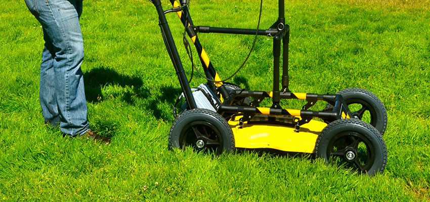
Ground Penetrating Radar (GPR)
Ground Penetrating Radar (GPR) is one of the latest techniques utilized in the location of underground utilities. A GPR signal is sent to the ground via a transmitter. Some portion of the signal will be reflected from the metallic or non-mettalic utility that is recorded with a receiver.

Sonde Locators
Sondes are used to locate nonmetal sewer pipes, storm drains, and conduits. Sondes also used to locate cast iron drain pipes. A sonde is a small radio transmitter inserted into a pipe. Once inside, a conventional pipe locator is used to locate the sonde. The pipe’s position is then marked on the ground. The sonde is pushed further into the pipe, the receiver relocates the Sonde and the pipe’s position is again marked. This process is repeated until the desired section of pipe is traced. Another option is to have a plumber snake the pipe. We can attach a transmitter to the snake and trace the line from the signal the snake emits. more
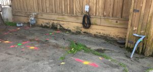
Deliverable results can range from a simple marking on the ground surface to a PDF report with images and a line overlay, a CAD drawing, or geo-referenced aerial imagery that documents the survey results. Any depth estimates should be considered approximations, as they are derived solely from the non-intrusive equipment. more